

Fiddien – Wayside Chapel (Ref: pfm130177)
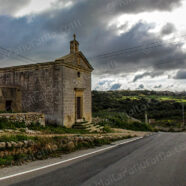
A lonely chapel at ‘Tas-Salib’, limits of Fiddien. The original small church dedicated to ‘The Nativity Of Our Lady’ was built in the area in 1550 which remained closed for many years. The present chapel was re-built on the same site in 1615 by Gregorio Xerri and his wife. These days prayer meetings are held in the chapel. Source: http://allaboutmalta.blogspot.com/2011/01/wayside-chapels-6-nativity-of-our-lady.html Location Map for Chapel in Fiddien: View Chapel of The Nativity Of Our Lady at Fiddien in a larger...
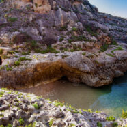
Read MoreSiggiewi – Ghar Lapsi (Ref: pfm140176)
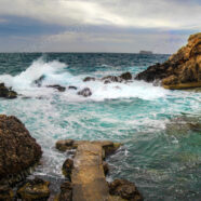
Rough seas battering the rocky caves in Ghar Lapsi in Siggiewi. This is more of a hidden cove rather than the normal definition given to a beach. It is situated around one kilometre from the popular Blue Grotto and is nestled underneath a less dramatic drop of Dingli Cliffs. Ghar Lapsi is a natural rocky swimming pool with a cave to compliment the beautiful surroundings. It is particularly popular with snorkelers due to being a naturally protected spot and with divers as an underwater shallow cavern leads out to the open Mediterranean Sea. Apart from a few small areas of flat rock, there is...
Read MoreBirgu – Fort St.Angelo (Ref: pfm140175)
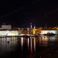
A view of Fort St.Angelo and Birgu (Vittoriosa) from Senglea at night. Fort St. Angelo is the jewel in the crown of The Maltese Islands’ military heritage. According to legend, the fort stands on the site of a fortified Roman settlement. When the Knights arrived on the Island in 1530, the Fort became the seat of the Grand Master of the Order. It was to play a heroic role in the Great Siege of 1565, when, against all odds, it managed to repel a formidable Saracen armada. The epic resistance of the Knights during the three-month siege gave the Fort its legendary status. In the 19th century,...
Read MoreFilfla (Ref: pfm110174)
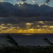
The wintry sun rays passing through the clouds over Filfla. Filfla is a small, barren, uninhabited islet 5 kilometres (3.1 miles) south of Malta, and is the most southerly point of the Maltese Archipelago. Filfoletta, a small rocky islet some 100 metres (328 feet) southwest of Filfla, has the southernmost point of Malta. The name is believed to come from filfel, the Arabic for a peppercorn. Filfla has an area of just 6 hectares (15 acres) and is a crumbling flat-topped limestone plateau surrounded by 60 metres (197 feet) high cliffs. Three species of sea birds breed on the islet: the...
Read MoreGozo – Wied Il-Ghasri (Ref: pfm120173)
A panoramic shot of the unique Ghasri Valley in Gozo – another of those elusive beautiful spots which are rather difficult to find. Wied il-Ghasri (reached through Ghasri and Marsalforn) is a fjord-looking tiny beach wedged between high cliffs and can be reached ideally by boat. The fantastic cove and airlock are the main attractions at this dive site. Source: http://www.islandofgozo.org/place?id=88&item=wied-il-ghasri-bay Location Map for Wied Il-Ghasri: View Wied Il-Ghasri in a larger map
Read More